Travel in South Africa - from Klerksdorp to Cape Town

Table Mountain, Cape Town

South Africa is but only a small part of Africa

A road trip to Cape Town
Visiting Cape Town from time to time seems to be a yearning deeply rooted in the genes of European-South Africans, because that is where 99.9% of our Western ancestors set foot on shore since 1652.
My own paternal ancestor, Jacob Kützer, and maternal ancestor, Barend Pieters, both from Germany, came as soldiers in 1709 tasked to protect the white settlement against the onslaughts of the natives - the San, the Koi and the Xhosa_people, who obviously felt threatened and disregarded, observing changes they had never foreseen. Like many others, my ancestors had decided to stay in South Africa instead of returning to a war-torn Europe. Farming - providing fresh food to sailors and locals - obviously held more rosy promises than soldiering for them.
Read more about the history of the Cape Colony here.
Heading for Cape Town via Bloemfontein, we departed from the southern part of the North West Province (Klerksdorp) on 17 October – the end of spring, beginning of summer. Driving through the ostensibly boring Orange Free State and even more boring, arid North Cape Province, we thoroughly enjoyed the landscapes, the characteristics of the towns along the road and the heart-stirring history of the regions. Of course, we could not see ‘everything’, and we may have missed some very interesting detail, but I believe that the reader will find this virtual tour insightful and enjoyable.
The Atlantic Ocean, Cape Peninsula, South Africa

From Klerksdorp to Cape Town

From the North West Province to Cape Town
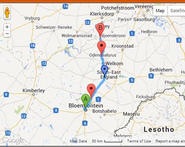
Travelling from Klerksdorp, which is located in the southern part of the North West Province, to Cape Town the most obvious route to choose would be -
- Klerksdorp (North West Province)
- Bloemfontein (Orange Free State)
- Colesberg (Northern Cape)
- Worcester (Western Cape)
- Cape Town (Western Cape
This will take the traveller fifteen and a half hours by car, excluding breaks.
South Africa

Please note:
This hub is not meant to be a comprehensive article about tourism in South_Africa, but a virtual road trip that will give the reader a pretty good idea of natural sceneries along the road. The pictures were taken during the last half of October, the beginning of summer in South Africa. My references to races and languages spoken in the various regions will give the reader an idea of South Africa's most unique and interesting multi-racial environment resulting in a richness of culture unmatched in this world.
Due to Racial Segregation, which was from 1948 to 1994 enforced in South Africa through legislation called Apartheid, each and every town and city in South Africa still have adjoining townships where either Africans, Coloureds or Indians prefer to stay in spite of their democratic right since 1994 to own houses in towns and cities that were previously reserved for 'only whites'. In this hub the reader will also see pictures of houses and roads in townships.
Departing from Klerksdorp
Situated in the North West Province of South Africa, Klerksdorp was founded in 1837 when white pioneers - the Voortrekkers - settled on the banks of a stream called the Schoonspruit ("Clear stream"). Klerksdorp is the oldest European (white) settlement north of the Vaal River.
At present the main languages spoken in this region are Tswana (42.7%, Afrikaans (23.8%), Xhosa (11.7%), Sotho (10.7%) Other languages, including English, Indian and Yiddish, (10.7%).
According to crime statistics in South Africa, Klerksdorp is still in comparison to other major towns and cities considered one of the safer locations in the nation. Sadly, South Africa is according to 2014's crime rankings the FIFTH dangerous country in the world.
Read more about Klerksdorp here.
Klerksdorp, the City of People
Click thumbnail to view full-size


")


")


Orkney
Within fifteen minutes from Klerksdorp we drive through Orkney, a little gold mining town on the border of the North West Province and the Orange_Free_State . Here the Vaal River, the largest tributary of the Orange River, is the actual border between these two provinces.
Orkney
Click thumbnail to view full-size


The Vaal River

R30 from Klerksdorp to Bloemfontein
Orange Free State - From Bothaville to Bloemfontein
45 Minutes after we have crossed the Vaal River at Orkney we find ourselves in Bothaville, the ‘capital’ MAIZE city of South Africa. Heading for Bloemfontein – ±3 hours road trip to the south – we get pretty bored seeing only dry grasslands ideal for pasture and/or crops such as maize, lucerne and sunflowers. Spotting a silo or a windmill, or grazing cattle and game, are the only highlights.
Between Bothaville and Bloemfontein
Click thumbnail to view full-size


")


")


BTW, the difference between mealies and corn in South Africa

 - the second most important grain crop produced in South Africa")
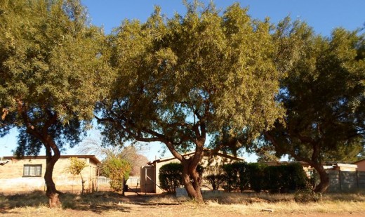
Bloemfontein
Bloemfontein (Fountain of Flowers) - where I was born and raised until the age of ten - is the capital city of the Free State and, as the judicial capital of South Africa, one of the country’s three national capitals. (The other two capitals are Cape Town (the legislative capital), and Pretoria (the administrative capital). Bloemfontein was founded in 1846 originally as a British outpost. Read more about Bloemfontein here.
Languages spoken are Afrikaans (42.5%), Sotho (33.4%), English (7.5%), Xhosa (7.1%), Other (9.5%).
NB: Most of the pictures I have taken are of historical buildings – the Bloemfontein of my childhood.
Bloemfontein
Click thumbnail to view full-size

 Bloemfontein, built in 1849. (I was baptised in this church)")


 Local Municipality.")


")
 women and children in British concentration camps during Anglo-Boer War II (1899-1902)")


 Bloemfontein, built in 1849. (I was baptised in this church)")


 Local Municipality.")


")
 women and children in British concentration camps during Anglo-Boer War II (1899-1902)")
Springfontein
Approximately one and a half hour from Bloemfontein is a small mixed farming town called Springfontein (Jumping Fountain). After checking the Hendrik Verwoerd Dam, now known as the Gariep Dam, we decided to spend the night in Springfontein’s classic hotel, reliving its forgotten glory.
Springfontein
Click thumbnail to view full-size


Gariep Dam
In the Orange River, on the border of the Free State and Eastern Cape Province, is the Gariep Dam - the largest storage reservoir in South Africa completed on 31 August 1969. The adjoining hydro-electrical power station houses four 90 MW generators, giving a maximum output of 360 MW of electricity. Read more about the Gariep Dam here and here.
According to travelstart.co.za, the Forever Resort at Gariep Dam is one of the 25 bests holiday resorts in South Africa.
Gariep Dam
Click thumbnail to view full-size


The Orange River
Only an hour by car from Springfontein, we cross the Orange River - the border between the Free State and Northern Cape Province. The Orange River is the largest river in South Africa and, as the Orange Free State, named after the Dutch Royal House. In the New Democratic South Africa (since 1994) the Orange River is rather called the Gariep River, as it was called by the earliest pre-colonial inhabitants.
It will forever be a mind-blowing fact that the Voortrekkers (Dutch pioneers) managed to cross this river in wagons that were pulled by oxen during the 1830's. Read more about the Voortrekkers here and here.
The Orange River

The Groot Trek

Colesberg
On our route from the North West Province to Cape Town, Colesberg is the first town we get in the Northern Cape Province. Founded in 1830, the town was originally named after an interesting hill, Toverberg, (magic mountain), but under British rule the hill and town were renamed after Sir Galbraith Lowry Cole,
This town/region is known for its large sheep farms and racehorse stud farms. The main languages spoken here are Xhosa (59.5%), Afrikaans (33.1%), Sotho (2.8%), English (1.8%), Other (2.9%). Read more about Colesberg here.
Colesberg
Click thumbnail to view full-size


 here - http://en.wikipedia.org/wiki/Reformed_Churches_in_South_Africa")


 was renamed after Toverberg after a nearby hill, it was renamed after Sir Galbraith Lowry Cole,")


 here - http://en.wikipedia.org/wiki/Reformed_Churches_in_South_Africa")


 was renamed after Toverberg after a nearby hill, it was renamed after Sir Galbraith Lowry Cole,")
From Colesberg to Matjiesfontein
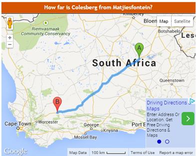
Between Colesberg and Beaufort West
We find ourselves now in a very interesting region called the Great Karoo – a semi-desert that was ± 320 million years ago an inland sea with wide swampy deltas - the natural habitat of ancient reptiles, andamphibians and dinosaurs. Read more about the Karoo here.
Heading for the next large town, Beaufort West - ±three and a half hours from Colesberg - curiosity encourages us to take a quick trip through some of the smaller towns along the N1, among others Hanover,_known for its powerful fountain (spring) that releases about 205,000 litres (± 54155 US gal) of water per day. This is where the famous author of 'The Story of an African Farm' , Olive Schreiner, and her husband lived from 1900 to 1907. The Karoo air is well known for its ability to relief/cure asthma.
What amazes us the most, and not only during this trip: While some towns and cities are bursting out of their boundaries, forever expanding and cluttered with modern buildings, time came to a standstill in many of the old towns somewhere in the beginning/middle 1900s. Driving through an old town arouses nostalgia and a longing to a time when over-population, crime and the urge or obligation to 'perform' were not the order of the day.
Hanover
Click thumbnail to view full-size


Richmond
Richmond is another charming little town in the Upper Great Karoo, displaying the original, well-maintained Victorian and Edwardian Karoo style buildings. Richmond was established in 1843 to meet the religious needs of the farming community. Those days a church was built to serve all farmers in a specific region with sermons, confirmations, baptizing, the Holy Communion, etc. Entrepreneurs of all sorts grabbed the opportunity to erect shops in the vicinity of the church in order to deliver services to the farmers who came from far and near in their ox-wagons to gather for the entire weekend on the church plain.
As a matter of interest, although it is a bit complicated: The Dutch Reformed Church (Protestants) originated in the 17th century (1652 onwards) in the Cape Colony from the Dutch Reformed Church of the Netherlands (Nederduits Gereformeerde Kerk). In the late 1830’s the Voortrekkers broke away from the Cape Colony – ref the Great Trek to the North - and formed a sister-church. They used the ‘new’ word ‘hervormde’, instead of the old word ‘gereformeerde’. (Both means ‘reformed’). Hence the ‘new’ church was named Die Nederduitse Hervormde Kerk. Then the original Dutch Reformed Church in the Cape Colony started to re-use the original word, ‘gereformeerde’. Unsuccessful efforts to reunite the two ‘sisters’ resulted in the establishment of both sister churches wherever the Voortrekkers founded towns north of the Orange River. Then, in 1859, some of the members of the (original) Dutch Reformed Church refused to accept the new hymn book and broke away to form the third sister-church, the Reformed Church (Gereformeede Kerk).
Considering the wars between Catholics and Protestants in Europe, the Catholic Church was forbidden in South Africa until 1795. The first Anglican churches came with the British when they occupied the Cape_Colony in 1795 until 1802 (after the Battle_of_Muizenberg), and then again in 1806 after the Battle_of_Blaauwberg.
As the years went by many members of the original three sisters churches broke away to form charismatic churches in accordance with their interpretation of the Bible. Today in South Africa the list of churches is as long as my arm.
Richmond
Click thumbnail to view full-size


Three Sisters
Three_Sisters is a well-known landmark on the route between Cape Town and the northern provinces of South Africa. It is the place where travellers via Bloemfontein and travellers via Kimberley meet to continue their trip to Cape Town on the same route, the N1. Three Sisters is named after three unique hills better known as ‘koppies’ (cups) in South Africa. These koppies are topped with dolerite (diabase/microgabbro) – an equivalent to volcanic basalt or plutonic gabbro.
Great Karoo between Colesberg and Beaufort West
Click thumbnail to view full-size


 sisters between Colesberg and Beaufort West, Great Karoo, South Africa")


 sisters between Colesberg and Beaufort West, Great Karoo, South Africa")


Read the most interesting article about the Karoo here -

Beaufort West… at last!
Between the Gamka and Kuils Rivers is Beaufort_West, founded in 1818. This was the first white settlement in the Great Karoo and is today the largest town in this area of the Central Karoo. Its economy is mainly based on sheep farming. Read more about Beaufort West here.
Languages spoken in this town are Afrikaans (81.2%), Xhosa (13.6%), English (2.6%) Other (2.7%).
According to some sources Beaufort West is actually located in the Little Karoo and not in the Great Karoo. Geologically the area between the Swartberg (Black Mountain) and the Langeberg Mountains is known as the Little Karoo.
The traveller, however, can't really see the difference between the Great and Little Karoo, or the Upper, Central or Lower Karoo. All of it looks bleak and semi-desert. Yet, knowing the stories and poems of people living in this region, we know that it has a magical power, capturing the heart and soul of its inhabitants.
Read more about the Little Karoo here.
Beaufort West
Click thumbnail to view full-size


From Beaufort West to Lainsburg

Beaufort West to Laingsburg
From Beaufort West to the next significant town, Laingsburg, we face another stretch of almost three hours through the relentless dry and hot Great Karoo, which is equally dry and cold during winters.
However, the Karoo has a worse part, called the Moordenaars (Killer) Karoo. One of the towns in the Moordenaars Karoo is Sutherland, the coldest town in South Africa, holding the lowest temperature of −20.1 °C (−4 °F) during winter when snowfall is quite common in contrast to 95% of South Africa.
South_African_Astronomical_Observatory (SAAO), the national center for optical and infrared astronomy in South Africa, with links worldwide for scientific and technological collaboration, is located in Sutherland.
Fortunately the main route between the north (Johannesburg) and Cape Town, the N1, doesn't take the traveller through the Moordenaars Karoo.
Moordenaars Karoo

Sunset in the Moordenaars Karoo

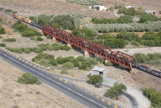
The Blokhuis, Laingsburg
Just before Laingsburg something out of the ordinary captures the traveller’s mind – a ‘blokhuis’ that was erected by the British during the Second Anglo-Boer War 1899-1902 in their effort to guard the railway bridge which enabled the transport of weapons and food by train. (Even the horses of the British were not able to digest South Africa’s natural vegetation.) While the British burnt all farms and held the women, children and elders of the Boere captive in concentration camps, and also their African employees in separate camps, causing the death of more than 26 000 women and children (while the death-roll among the Africans was not even recorded), the Boere used hit-and-run guerrilla tactics in their efforts to deny the British supplies and refuge. 93,940 Boers and 24,457 black Africans were reported to be incarcerated in concentration camps. Of the 28,000 Boer men captured as prisoners of war, 25,630 were sent overseas. Thousands were not able to return to South Africa.
Considering this tragedy, I find the Apartheid's policy that was eventually legalized by the 'Boere' in 1948 even more sadder. Amazing how people, once they come into power, also practice the injustice they have suffered in some way or the other while they were powerless. Read more about the Second Anglo Boer War at britannica.com.
NB: The name 'Boere' refers to Afrikaans-speaking whites, the descendants of Dutch, German and French Europeans. 'Boer' is actually the Afrikaans word for 'farmer'.
The Blokhuis
Click thumbnail to view full-size


Laingsberg
On the route to Cape Town, Laingsberg is the first town located in the Western_Cape Province. It lies at the confluence of two rivers, the Buffalo and Baviaans. It is considered to be one of the driest parts of South Africa.
The entire town was almost swept away in 1981, when abnormal rainfall in the catchments of both rivers caused an unexpected flood, claiming 104 lives and 21 buildings.
NB: The Western Cape Province (including Cape Town) is the only province in South Africa that is not run by the ANC government. The leading political party in this province is the Democratic Alliance, obviously due to the fact that Africans - the majority supporters of the ANC - are not the majority inhabitants of this province. The population groups in this province are Coloured (48.8%), Africans (32.8%), White (17.3%), Indian/Asian (1%).
In Laingsburg the languages spoken are Afrikaans (93,6%), English (1.7%), Xhosa (1.6%), Other (3.1%). NB: Afrikaans is also the language of the majority Coloureds.
Laingsburg was established in 1881 mainly because the extended railway route from Cape Town happened to run past the farm of Stephanus Greeff. He then grabbed the opportunity to develop the farm into a small town. Read more about Laingsberg here and here, including the unexpected flood that had swept away the largest part of the town on 25 January 1981.
Laingsburg
Click thumbnail to view full-size


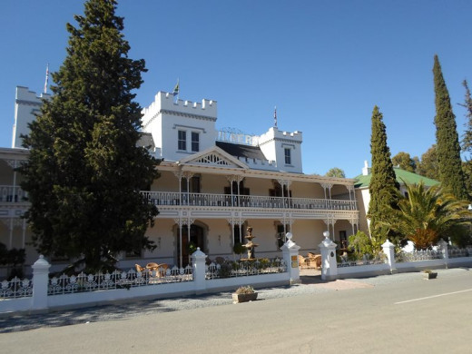
Matjiesfontein
From the north to the south, almost at the end of the Karoo, we reach the most charming Victorian village, Matjiesfontein (fountain of little reeds). It is actually only one railway station and a street containing a hotel and a few houses.
The history of Matjiesfontein is totally captivating, about James Douglas (Jimmy) Logan. As a young lad Jimmy joined the North British Railway at Reston in Scotland, but at the age of 17 he went to sea. Two years later (1876), stranded in a waterlogged ship at Simons Bay (near Cape Town) with only £5 in his pocket, he decided to apply for a job at the Cape Colonial Railways, which was still an infant. By the time he was 20, he was appointed as stationmaster of the newly completed Cape Town Station. Diamonds were discovered in Kimberley in 1866, and travellers from Cape Town to Kimberley were in dire need of accommodation and food. The railway dining cart was not yet introduced, so Jimmy grabbed the opportunity to establish refreshment rooms at railway stations. This was the beginning of his wealth and fame.
Cured from his chest ailment by the dry Karoo air, he made Matjiesfontein his headquarters. By then he was the husband of Emma Haylett (of Cape Town) and the father of Jimmy and Gertrude.
During the Second Anglo-Boer War (1899-1902) the British established a remount camp on the outskirts of Matjiesfontein with 10,000 troops and 20,000 horses. Go figure! At the end of the war, by-passed by a National Road to the north, Matjiesfontein started to sink into obscurity. When Jimmy died in 1920, Matjiesfontein was just another railway station and homestead of the Logan family.
In 1968 David Rawdon, in his capacity as hotelier, bought the village and restored it to more than its original fame.
Matjiesfontein was declared a National Heritage Site in 1975.
Matjiesfontein
Click thumbnail to view full-size


Matjiesfontein - I was utterly surprised to find an entire 'house' beneath the station - once the headquarters of Jimmy Logan, now the The Marie Rowdon Museum
Click thumbnail to view full-size


From Matjiesfontein to Cape Town

From Matjiesfontein to Cape Town
A three hours road trip to Cape Town lies ahead of us...
Read all about this second phase of our journey at From-Matjiesfontein-to-Cape-Town.......

Travelling in South Africa
Find many more virtual tours of South Africa here.

© 2014 Martie Coetser


